Collection
Explore
Featured collections
Highlights
Explore by maker
Explore by subject category
Bird's eye view
Colours
Advanced search
My shortlist
Back to main website
×
Searching for:
Search
Object
Person
Refine Results
Refine results
Collection
Sites
1995
Images attached
Yes
1250
No
745
Image Orientation
landscape
516
portrait
76
colour
More
Sort By
Relevance
Recently added
Accession number
Name/title
Collection
Department
Sort Descending
View
List
Label
Lightbox
More Options
View
List
Label
Lightbox
Shortlist
Add All to Shortlist
1995 results. Displaying results 1 - 40.
«
1
2
3
4
5
»
Brown and Wardrop (completed as Wardrop and Reid) 1869-77 in present external form being Francois Ier remodelling of earlier house of several dates with total frontage of 300', viz:- NW angle of main block small tower house probably late 14th century; extended to L-plan by wing running eastwards 54' linked at S gable, extended a further 88' mid 17th century and then by a further 40' to produce an approx. symmetrical 3-storey house of 182' frontage with single pile centre and double pile ends, centre of north front being recessed with octagonal stair turrets; low 2-storey L-plan wings added at ends late in 17th century to bring total frontage to 300'; Internal alterations proposed (?if executed) James Craig 1785, Internal alterations David Hamilton 1827, scheme for further additions 1830, not executed. Remodelled 1869-77, original harled surfaces and openings retained but more embellished with French architectural features carried out in coursers or ashlar, principally twin bay windows corbelled to square at 2nd floor with high French roofs, double staircase and 1st floor balcony south front, large triple stairhall block with high pavilion roof and angle turrets, single-storey entrance hall and porch with balconied platform roof north front tourelles added angles of main block, high French roofs added over end sections of main block and wings chimneys rebuilt with diamond panels. Interior:- various dates, old staircase much renewed early in present century after fire damage, fine baroque painted ceiling, neo Greek pilastered and barrel vaulted library, small drawing room David Hamilton 1827, remainder modified or remodelled by Wardop.
Sites and Monument Record: Callendar House (SMR 562)
Add to Shortlist
This lectern doocot stands near the W end of Dovecot Rd, Westquarter. It is in an excellent state of preservation, the roof having been renewed by Historic Scotland. Slightly oblong in plan, it measures 18 ft 3 ins from E to W by 16 ft 3 ins transversely over walls 2 ft 10 ins thick, and is built of random rubble with dressed quoins and door-rybats. The door is in the centre of the S side, and above this a heavy round perching course runs all round the building. Resting on this above the door is an heraldic panel topped by a small moulded cornice, above which there is a row of three openings for the birds. From the wall head of the S wall the roof slopes up towards the N wall, which is considerably higher, the slope being interrupted to provide space for a further row of sic openings for pigeons. The side walls are crow-stepped to a point about half way up the upper portion of the roof, where they meet the returns of the tabled parapet that tops the N wall. This parapet is finished with scrolls and pilasters, and bears ball finials at the corners. The inner faces of the walls consist wholly of stone built nests, which number 868; they are built in regular rows each about 9 ins high. The floor is laid with bricks, in which a circular setting marks the socket hole of the vanished potence. The armorial stone is fully described in the noted documentation. Dated 1647.
Sites and Monument Record: Westquarter House Doocot (SMR 55)
Add to Shortlist
A doocot is mentioned in connection with Woodside in the Edinburgh Evening Courant on the 20th June 1793. This may have been at the stable bock Woodside became known as Glenbervie.
Sites and Monument Record: Woodside House Doocot (SMR 56)
Add to Shortlist
An ice-house is said to have been in use at the hospital here earlier this century.
Sites and Monument Record: Bellsdyke Hospital Ice-house (SMR 59)
Add to Shortlist
The ice-house lies c90 m E of Carriden House, almost at the top of a wooded N-facing escarpment leading down to the Forth Estuary. It is perhaps in a better state of preservation than any of the other ice-houses in the District. The ice-chamber is 3.2 m in diameter and at least 2 m deep below the foot of the entrance door which is on the N. The roof is domed, with a circular aperture in the centre from which a square shaft c90cm long gives access to the outside. This is now covered with a manhole cover and would have been used to load the ice. The whole structure is of brick, the inside walls have been whitewashed. The antechamber communicates with the outside by three steps with checks for a door opening outwards. A door was also fitted at the entrance to the ice-chamber. The walls of the entechamber are irregular and curve in towards the main chamber. On the W side is a large recess, which may have been a larder. The antechamber has a barrel vaulted roof. The whole is covered externally by earth and the facade plainly retained by stone walls. Ice may have been obtained from the
Sites and Monument Record: Carriden House Ice-house (SMR 61)
Add to Shortlist
This ice-house was situated at the foot of a N facing slope which in 1860 formed a strip of wooded land. The OS map shows a path descending the hill to the E of the ice-house and curving in to an access on the N side of a rectangular structure. The site lay c230 m N of the house, and is now separated from it by the M9 motorway. No trace remains above the ground, other than a scatter of stones. Ice could have been gathered from an artificial pond 150 m W of Kinnaird House.
Sites and Monument Record: Kinnaird House Ice-house (SMR 67)
Add to Shortlist
The ice-house lies near the foot of a N facing wooded slope c20 m NNW of the house. The facade is of the plain stone rubble construction topped by round capping stones. Two buttress walls project forward at right angles to the main face. To either side of the checked doorway are small ventilation openings which were once protected by an iron grill. From these shafts led to the air gap around the ice-chamber itself. This chamber is reached from a vaulted antechamber with a second door at the interface between them. The chamber is egg-shaped and constructed of brick. The dome is still intact and has a loading hatch at the apex. The whole of the structure is buried under a mound of earth which projects from the natural hillslope. The two iron doors are now detached and rotting in the vicinity.
Sites and Monument Record: Larbert House Ice-house (SMR 69)
Add to Shortlist
Grassam's map of 1818 shows an ice-house on the W side of Icehouse Brae. It is also commemorated in the name Icehouse Well (Love,J III, 333) noted for its soft water. A plan in the SRO shows this the modern planting around a circular ice-house. Nothing can now be seen on the surface.
Sites and Monument Record: Laurieston Ice-house (SMR 70)
Add to Shortlist
An ice-house with a brick built circular ice-chamber set in puddled clay was demolished by the Amenity And Recreation Dept of FDC in 1980 as part of their development of the estate as a country park.
Sites and Monument Record: Muiravonside House Ice-house (SMR 71)
Add to Shortlist
An interesting ice-house with a right-angled bend in the entrance passage to reduce drafts. The entrance door faces N but is shielded by the retaining wall of the E facing bank into which it is cut, giving it an E aspect. The door is only 1.2 m high, and the first 1.2 m of the passage is only 1.4 m tall. The ceiling then slopes up to 1.97 m. The walls are brick built, but the roof of the passage consists of 8 large flat sandstone slabs accurately chamfered to fit tightly together. A second door stood at the entrance to the ice-chamber which is rectangular in shape, 3.75 m by 3,7 m. The walls are of a high quality facing brick with a brick vaulted roof. In the centre of the roof is a square aperture formerly fitted with an iron frame and cover. The aperture, 0.6 m by 0.45 m in size, leads to the top of the earth mound after 60 cm. The ice-house is built into the E facing back of a cutting through which an estate road runs in a N-S direction. The top of the mound is thus level with the field to the W. The 1860s OS map shows this as a wooded area, but at this date the estate road lay further W. By 1921 it is noted by the OS as "Old Icehouse". The ice-house must date to the later part of the 19th century. It is c130 m from the house, and is now owned by Parkhall Farm who are slowly filling it in with agricultural debris. As the open top presents a hazard to animals the structure is unlikely to survive long. The Union Canal lies some 350 m to the N. by
Sites and Monument Record: Parkhall House Ice-house (SMR 72)
Add to Shortlist
A structure, 100 m NE of the house, now known as the Crow Well, may formerly have served as an ice-house. It lies about one third of the way down a steep wooded N facing slope. The remains consist of a well dressed stone retaining wall in the shape of a semi-circle with projecting wings. The back of the arc rises in height, as does the earth which it retains. In the centre is a much damaged opening through which water trickles. The lintel now lies some distance in front of the opening. It has a series of ogee mouldings on its face. Behind the retaining wall a slight hollow might indicate the position of a collapsed ice-chamber. On the W side stone steps ascend the slope towards the house and a formal garden terrace. Ice could have been obtained from ponds 200 m to the E adjacent to the Polmont Burn.
Sites and Monument Record: Parkhill House Ice-house (SMR 73)
Add to Shortlist
Situated on the W bank of the Union Canal near a road crossing. Shown on the 1860s OS map with a railway running alongside the canal before turning to feed the kilns. The kilns would have been for large-scale production of lime for the Almond Foundry.
Sites and Monument Record: Almond Foundry Limekiln (SMR 77)
Add to Shortlist
Dunmore Village - Interesting example of mid c19th estate development.
Sites and Monument Record: Rose Cottages, Dunmore (SMR 194)
Add to Shortlist
5 of the dwellings in Dunmore Square are listed as a unit. Other buildings will be found in separate entries.
Sites and Monument Record: Dunmore Square (Moss Cottages) (SMR 196)
Add to Shortlist
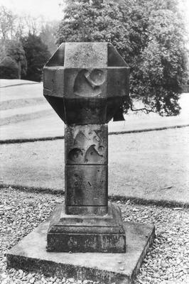
Sites and Monument Record: Callendar House Sundial I (SMR 563)
Add to Shortlist
The house stands in an extensive estate 1 km NW of Airth. It was built for George, 5th earl of Dunmore, between 1820 and 1822 to the designs of William Wilkins. It is in his usual Tudor Gothic style and is built around a courtyard. The main entrance lies to the SW and is covered by a porte cochere. Ruined gothic mansion, partly demolished Tudor design by WIlliam Wilkins 1820-22.
Sites and Monument Record: Dunmore Park House (SMR 200)
Add to Shortlist
The ice-house stands prominently 130 m N of the house it served. The tall sandstone frontage is topped by a pediment, below which the doorway faces W. This orientation is due to the wish to display the building as a landscaped feature of the park, and in its location it would have been just as easy to face it N. It is built into the side of a disused gravel quarry. The antechamber is 3.65 m long and leads into the circular ice-chamber, 3.66 m in diameter, with its domed roof. Ice-chamber and antechamber are built of brick. Originally the ice-pit was 3.65 m deep from the floor of the antechamber, and given the gravel drift geology was presumably self-draining. The ice chamber was filled with gravel and other loose material by the Department of Amenity and recreation to bring it up to ground level, and it was subsequently used as a goat house. The antechamber had a door at either end, plus a third about mid way along. A small loch and ornamental canal lie 200 m to the S and would have provided ample ice. In September 1789 William Forbes received information on ice-houses elsewhere being intent upon erecting one at Callendar. These plans were made in "great haste" (GD 171,359/15).
Sites and Monument Record: Callendar House Ice-house (SMR 60)
Add to Shortlist
The site lies to the north of the Larbert Branch railway and on the southern margin of Camelon Golf Course and the west of Stirling Road. It lies on an elevated plateau above the River Carron, which has changed its course since the Roman period. The ramparts survive as prominent mounds, circa 4ft high.
Sites and Monument Record: Camelon Roman Fort (SMR 1)
Add to Shortlist
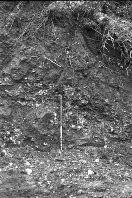
Sites and Monument Record: Craigenbuck Shell Midden (SMR 218)
Add to Shortlist
It is unknown whether this is a natural deposit or a shell midden. Molluscan samples were recovered from the garden area of the cottage. These suggest the material is of natural origin, although there may be an element of shell midden involved.
Sites and Monument Record: Shelly Bank Shell Midden (SMR 220)
Add to Shortlist
Load More Records
«
1
2
3
4
5
»