Collection
Explore
Featured collections
Highlights
Explore by maker
Explore by subject category
Bird's eye view
Colours
Advanced search
My shortlist
Back to main website
×
Searching for:
Search
Object
Person
Refine Results
Refine results
Collection
Sites
1995
Images attached
Yes
1250
No
745
Image Orientation
landscape
516
portrait
76
colour
More
Sort By
Relevance
Recently added
Accession number
Name/title
Collection
Department
Sort Descending
View
List
Label
Lightbox
More Options
View
List
Label
Lightbox
Shortlist
Add All to Shortlist
1995 results. Displaying results 161 - 200.
«
3
4
5
6
7
»
Also known as Nether Saltcoats or Monteith Saltcoats.
Sites and Monument Record: Easter Saltcoats (SMR 1998)
Add to Shortlist
The location of the Airth pans is not known.
Sites and Monument Record: Airth pans (SMR 1997)
Add to Shortlist
Sites and Monument Record: Avonbridge parochial School (SMR 1995)
Sites and Monument Record: Avonbridge parochial School (SMR 1995)
Add to Shortlist
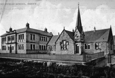
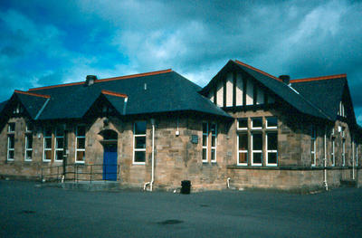
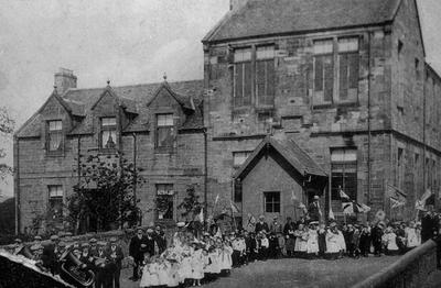
Sites and Monument Record: Denny Primary School (SMR 1988)
Add to Shortlist
Lawhill School was built 200m east of Broadside Farm to the west of Denny. It appears on the first three editions of the OS maps and is a substantial stone building, now a private house.
Sites and Monument Record: Lawhill School (SMR 1987)
Add to Shortlist
Sites and Monument Record: Airth School (SMR 1986)
Add to Shortlist
The estate of Glenfuir was purchased by the Union Canal Company c1818 to provide a terminus to the canal. The canal and its basins were constructed in the west end of the estate and the house and the east end were then sold on. A lodge stood on Glenfuir Road beside the Forth & Clyde Canal. Demolished in the 1950s.
Sites and Monument Record: Glenfuir House (SMR 1985)
Add to Shortlist
Built on the Overton Burn to the west of Denny between the issuing of the 2nd and 3rd ed OS maps.
Sites and Monument Record: Overton Reservoir (SMR 1984)
Add to Shortlist
From the Faughlin Burn Bridge the drove road climbs the hill above the Carron Valley. It skirts Tarduff Hill to the south, with Darroch Hill on its south. Denny Muir provided opportunities for stances. The road then descends to Broadside where it is now lost amongst later developments. The drove road consists of two parallel drystone dykes set around 10m apart. It is probable that it was not metalled and that the cattle were able to graze as they moved. Their dung would have fertilised the way.
Sites and Monument Record: Drove Road (SMR 1983)
Add to Shortlist
This house is almost identical to Duncarron House at 76 Broad Street (see that entry). Built c1870.
Sites and Monument Record: Strathcarron (SMR 1982)
Add to Shortlist
Sites and Monument Record: Stenhouse Lodge (SMR 1981)
Add to Shortlist
Sites and Monument Record: Bo'ness Cooperative (SMR 1978)
Sites and Monument Record: Bo'ness Cooperative (SMR 1978)
Add to Shortlist
Sites and Monument Record: Bothkennar School (SMR 1976)
Add to Shortlist
A distinct mill leat can be seen from just below (east) the farm buildings at Skipperton to the site of this mill, running parallel with the farm access road. It has now been truncated by the Castlecary Branch Railway. It appears to have taken spent water from the known mill and led it to a second site where it could be re-used. It is not shown on any of the OS maps and is evidently very early.
Sites and Monument Record: Skipperton Mill I (SMR 1975)
Add to Shortlist
A circle of small boulders with earth piled around them measures c21m in diameter and sits on a raised platform immediately west of an old N/S boundary wall and c17m north of the modern WNW/ESE boundary wall. It is similar to Bronze Age hut platforms, or it may be the Druid's stones reported elsewhere.
Sites and Monument Record: Wester Barnego enclosure (SMR 1974)
Add to Shortlist
The substantial remains of this farmsteading include a pigeon left set into the south gable of an outbuilding, pig styes, outdoor toilets, and so on.
Sites and Monument Record: Buckieside (SMR 1973)
Add to Shortlist
A window lintel on the west side of the farm complex has the poorly carved date 1775. The first seven is reversed and the numbers are divided in tow and set at either end of the stone. There does not appear to have been any initials in between. The farm buildings have been deserted for some time, but are well preserved.
Sites and Monument Record: Stoneyinch datestone (SMR 1972)
Add to Shortlist
A single-arched stone bridge set at an obtuse angle to the stream 230m NE of Bonnyhill Farm It is not a true skew bridge and the angle is dealt with by allowing some of the arch stones to protrude beyond the parapet. Above the centre of the arch in the SE facing elevation is an oval panel containing the date 1831. The ends of the abutments are in poor condition and the NE parapet has been replaced with shuttered concrete.
Sites and Monument Record: Bonnyhill Bridge (SMR 1971)
Add to Shortlist
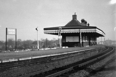
Sites and Monument Record: Camelon Station (SMR 1969)
Add to Shortlist
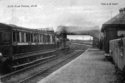
Sites and Monument Record: Airth (Carnock) Station (SMR 1968)
Add to Shortlist
Load More Records
«
3
4
5
6
7
»